Showing posts with label apps. Show all posts

Wednesday, January 15, 2014

Bushwalking Equipment | Can I Really Do Without a Smartphone?

As a bushwalker, can you afford not to own a smartphone? Which smartphone apps can replace dedicated equipment? What are the limitations?

Over the last few years technology has made smartphones invaluable to bushwalkers, replacing many of the devices, which previously had to be bought and carried individually.

Probably the first device carried by bushwalkers to be incorporated into the iPhone was the still and movie camera. Today's smartphone has a high quality camera which can take video and stills, including panoramas, mark each with the location at which the photo was taken, and then upload it to the web using wifi or mobile (cellular) data.

Next, the GPS became available, allowing routes to be mapped live, waypoints determined and marked, and distances accurately determined. Recently, apps which allow the viewing of calibrated digital maps have become commonly available, and some apps now incorporate the navigation features found in a dedicated GPS. High resolution colour screens make viewing these maps and navigational features easy. Modern smartphones have built-in compasses which can be calibrated and are accurate enough for the day walker, but not accurate enough for bearings over long distances.

Then high quality heart rate sensors came on the market which could pair with a smartphone, initially using a "dongle" plugged into the earphone socket but more recently using low energy interference-free Bluetooth.
 Some apps even use the smartphone camera and built-in light to measure blood flow pulses in a finger, without the need for an independent sensor. Fitness training had become more scientific!

The next advance was the ability to measure heart rate variability (HRV) (see previous post), using the powerful analysis capabilities of modern smartphones. Initially measuring HRV was only possible with expensive laboratory based equipment, but soon Polar had incorporated this ability into some of their top-of-the-line wrist computers. In the last few years, this technology has migrated to the smart phone, allowing bushwalk training to be fine tuned.

Bush walkers visiting remote areas often feel the need to take emergency devices with them to obtain help if an emergency occurs. We are all familiar with personal location beacons (PLBs) which can transmit a message, including location, to an overhead satellite, and from there to emergency rescue services.


SPOT gen3 s can send a message via satellite to your emergency contacts or to the same rescue service. Version three is much better functionally according to the reviews, but has a more expensive subscription.

Recently smartphone apps (GetHomeSafe) have become available which can send an SMS or email, if a bushwalker fails to return on time, without the need for any action by the "injured" or "lost" person or instantly in a critical emergency to a contact list or even rescue services directly, including the current location, participant details and a route plan. "You don’t need a working phone (be within range) or even to be be conscious for an alert to be sent."

Bush walkers on day walks and within range of a mobile tower, up to 70 km from a high enough vantage point, can add weather and tide apps  and the ability to visualise routes or places in 3D using Google Earth.

We now have GPS, fitness, navigation, mapping, emergency notification and weather services available at low cost in the one device! The only problem is a lack of battery capacity, but even this can be overcome to some extent with a solar charger.
What is next?
How do you overcome these limitations?
Where will the future take us?

  Creative Commons License This article by Bush Walker is licensed under a Creative Commons Attribution-NonCommercial-ShareAlike 3.0 Unported License.

Tuesday, January 14, 2014

Bushwalking Fitness | Pt 3 My Choice of Smartphone Apps for Fitness Training

Which apps should I choose to monitor my fitness? How should they be integrated? How should I fine tune my training, using the data collected?

As mentioned in the previous two posts, Part 1 and Part 2, technology incorporated into the smartphone and low cost, high quality apps now enable bushwalkers to monitor their fitness and training program in a way previously only achievable by elite athletes working in an  exercise laboratory. Both of these posts should be read as they provide necessary background for this post.

To maintain a high level of fitness, the bushwalker needs to be able to
Many of these can also be monitored by advanced wrist computers incorporating GPS and heart rate monitors, but these usually lack the versatility of a smartphone.

Measuring Personal Fitness

Polar Beat has an in-app purchase which allows your to do a Fitness Test (see previous post for more details) which you can then match with VO2max norms for your age and gender. This should give  similar results to the values produced by Polar OwnIndex® found in many of the high-end Polar wrist computers, but I have found them to be about 5 points lower.

iThlete, BioForce HRM, and HRV4training use HRV as an indicator of fitness, with higher values indicating higher fitness levels. I am currently trialling both iThlete and HRV4training and may continue with both, as they offer slightly different but important features.

iThlete enables you to log important "environmental" factors such as sleep, fatigue, training load, muscle soreness, stress, mood and diet and check for correlations with HRV scores. HRV4training automates the HRV measuring process, giving the option of lying down or standing or both. If this option is chosen, the difference between standing and lying down is automatically calculated and can give valuable information about fitness, as the difference increases with fitness.

Logging Training Sessions

Precision Pulse HRM monitors, HRaverage and HRmaximum, kCal burnt, and training load, as measured by an objective TRIMP score, determined by time in each training zone and heart rate. Without this knowledge, training loads become rather subjective, especially if there is variation in the type of activity, volume and intensity, and therefore affect the reliability of the HRV data.

I have been using Walkmeter ( Apple) for about 5 years and find it to be an excellent app for maintaining a log of your training sessions, including GPS location, Activity, Route, kCals, Heart Rate, Elevation climbed and Duration, which can then be graphed and mapped or viewed live. Most importantly it is very user friendly, making excellent use of the remote controller on the earplug to control start/stop, playing of motivational music and user defined voice announcements such as pace, time, progress in relation to worst, medium, best previous times for the route. This means you don't have to take your iPhone out of your pocket to control the app. It has the ability to automatically stop if you are stationary for more than a user defined duration, which is very handy. All of this information can be shared live using social media, if you are so inclined.

Polar Beat offers some of the above features  such as measurement of distance, calories, speed, heart rate, and provides voice announcements and map location,  but appears to be not yet fully developed. It does however integrate well with the Polar website.

Planning Future Training Sessions

Both iThlete and HRV4training provide bushwalker friendly advice about the day's training session by relating  the morning's heart rate and HRV measurements to previous days.

Careful analysis of data provided by Walkmeter, such as average and maximum heart rates, time in each training zone, and duration in relation to previous times, can provide a limited guide, but lacks the predictive ability of the first two apps..

Social Media and Web Integration

Many fitness apps allow social media integration with Facebook and Twitter, and may allow upload to a proprietary website, for more detailed analysis.

Related posts

Bushwalking Fitness | Pt 1 Smart Phone Apps to Fine Tune your Bushwalk Training
Bushwalking Fitness | Pt 2. Using a Heart Rate Monitor and a Smartphone to Measure Fitness Variables


  Creative Commons License This article by Bush Walker is licensed under a Creative Commons Attribution-NonCommercial-ShareAlike 3.0 Unported License.

Friday, January 4, 2013

Bushwalking Fitness | Is stretching a waste of time?

Is static stretching a waste of time? Does static stretching before exercise prevent muscle soreness and injury? Can static stretching beforehand reduce power during a bushwalk?
With a couple of  almost 3000m Canadian mountains (Mt.Begbie near Revelstoke and Mt Tupper near Roger's Pass) to climb in September, and with the festive season having played havoc with my fitness, I have again made my annual New Year's resolution to improve my fitness.

Mt Begbie, Revelstoke (© goldenscrambles.ca)
Mt Tupper, Rogers Pass (© Selkirk Mountain Experience)

My usual weekly keep-fit regime involves 3 or 4,  45 - 60 minute walks on rugged and hilly tracks near my home, interspersed with a Pilates class or two, and as I approach a major bushwalk/climb, 1 or 2 bushwalk-specific weight resistance sessions at my local gym. In hot weather, I cool down after  my morning walk with a 1 km swim.

While annual gym fees are substantial, cutting back on my wine consumption by a glass a day, more than pays for the cost! This training schedule may seem excessive to some, but I've found that to enjoy a bush walk, and in some cases a 10-12 hour day with a heavy pack, that a high level of fitness is needed. As I get older, it takes more effort to reach and maintain the same level of fitness.

Training Route, Brownhill (3.83 km)
I find that, as I usually train on my own, I need some incentive to improve and for this I  use the highly regarded iPhone app Walkmeter which enables me to compare my times from walk to walk and from stage to stage within the walk. It even allows me to select background music with appropriate BPM (beats per minute) and gives me feedback throughout the walk as to how I rate compared with my best, median and worst times at key points ( see map above) along this route. All of these statistics, including calories burnt, can be viewed online , exported to Google Earth (kml or gpx files) or shared with your training partner.

As I have been noticing a little calf muscle soreness during these walks, I thought I would investigate if a stretching regime could help. To my surprise, I found that the benefits of stretching were rather controversial.
Researchers Robert Herbert, Ph.D., and Marcos de Noronha, Ph.D. of the University of Sydney conducted a systematic review and meta-analysis of 10 previously published studies of stretching either before or after athletic activity. They concluded that stretching before exercise doesn't prevent post-exercise muscle soreness. They also found little support for the theory that stretching immediately before exercise can prevent either overuse or acute sports injuries.  (When to Stretch - Experts Recommend Static Stretching After Exercise ©2013 About.com. All rights reserved.)
Part 2 of this post outlines a bushwalk training session which has been designed for me by a professional trainer and includes a warm up with dynamic stretches, training walk, and a cool down including static stretches.

Other Bushwalk Fitness related posts (9)

Bushwalking Fitness
Bushwalking Fitness | Stretches for Bushwalkers
Bushwalking Fitness | Planning a Bushwalk Training Session

  Creative Commons License This article by Bush Walker is licensed under a Creative Commons Attribution-NonCommercial-ShareAlike 3.0 Unported License.

Thursday, December 29, 2011

iPhone App Review | Tide Prediction

Have you ever wanted to a walk safely along a beach, across a tidal estuary or around a rocky headland? Well of course you could check the BOM website from home before you left, but what if you had forgotten and only had your iPhone with you?
Sometimes knowing when high tide is going to be can be critical to planning a safe bushwalk. There are many locations where part of the walk will be along a beach, around a headland or across a tidal estuary. Often the guide book will warn that if the tide is high you must take and alternative inland route or even camp and wait for the next low tide. Being caught on an exposed headland as the tide advances is not much fun.

In Australia, I have used this information to safely plan walks along the Great Ocean Walk in South West Victoria and along the South Coast Track in Tasmania.

The following list of iPhone apps includes one that is actually a weather app which includes tides as one of its features.

AU Tides Pro
AU Tides Pro Screenshot
Contains downloaded database for 2010-2012, which means you don't need to be connected to the internet
World Tides 2012
Contain downloaded database for 2012 only, which means you will need to buy a new version at the end of 2012. This app only allows access to tide predictions 6 days ahead. World Tides uses the Simply Harmonic Formula and harmonic constants provided by the UKHO to give 7 day tide predictions without the need for an internet connection. Features: Moon/Sun Rise/Set times, large slidable tide graph, recent locations, built in zoomable map, gps sensor, search, and details page. 
Pocket Weather AU
Pocket Weather screen shot
I have used this as my weather app for over a year and don't see the need for an additional tide app. It does need internet access which makes it useless in remote areas, unlike the other three which actually download the tide database. Weather is sourced directly from the Australian Bureau of Meteorology (BOM) - an Australian Source for Australian Weather! #1 Weather Application in Australia, Best Australian App winner, Staff Pick in iTunes Store many times -
Shralp Tide (FREE)
Shralp Tide Screenshot
No network connection is required, so you can check anytime, anywhere. ShralpTide displays the current tide along with the high and low tides for the current day and the next 4 days. Includes an INTERACTIVE FULLSCREEN TIDE GRAPH in landscape mode. Turn the device on its side then touch the screen to see the tide at any time in the 24 hour window. Shralp Tide does not include all of the tide stations in the world. It has good coverage of the US and Canadian coasts as well as Australia, New Zealand and Japan. Beyond that there is spotty coverage of international locations.
The benefit of an iPhone tide app is that the calculations are done automatically for you if you select one of the non-standard ports. Of course, your iPhone probably has a GPS, in which case the app will work out what is the appropriate location on which to predict your tides.

You can of course use the Bureau of Meteorology's tide predictions available on their website, which are based on a series of "standard ports" around Australia. In Tasmania, Hobart is one of the five standard and one secondary ports with calculated tide predictions available. Time differences for a limited number of other secondary ports are provided so you can work approximate tide times yourself by adding or subtracting the time difference.( see map below)
From BOM
I don't know the technical side but my iPhone app Shralp Tide gives the following for Wednesday 28 December for the first high tide.
  • Maatsuyker Island (south of the bottom of Tasmania) high tide at 1.31 am as 0.69m
  • Hobart: high tide at 12.34 am of 1.05m
  • Bramble Cove : HIgh 3.17 am 0.78m
Bathurst Harbour is not listed nor Port Davey; you must use Bramble Cove.

BOM Tasmania gives Hobart as the nearest standard port and lists tides at secondary "ports" as a time difference from Hobart

Hobart HIGH at 1:02 AM 1:07m
  • Maatsuyker Island +0:25 H:M
  • Bramble Cove, near Port Davey is -0:48 H:M
  • Hobart 0:0
Using these differences the iPhone app gives a pretty close estimate except for Bramble Cove which seems to be way out!

PS Don't forget to allow for daylight saving if not done automatically by the app.


  Creative Commons License This article by Bush Walker is licensed under a Creative Commons Attribution-NonCommercial-ShareAlike 3.0 Unported License.

Sunday, December 18, 2011

iPhone Apps for Bushwalkers Revisited

It's over a year since I began reviewing iPhone apps for bushwalkers. During this time I have tried hundreds and found that I only use a few regularly.
While there are hundreds of iPhone apps useful to bushwalkers and growing every day, what you personally find useful is determined by your past experience, the type of walking you do, your interests,  and your willingness to be dependent on high tech devices.

After trying most, I regulary use only a few of these. On bushwalks, my choice will vary as it is dependent upon on the duration of my walk, and hence how important it is to save battery power,  and upon how much non-walking time I will have available.

My iPhone Apps

Navigation: Bit Map, Declination, Maps, Google Earth, Compass
Field Guides: Good Reader, BooksApp, Kindle, Aus. Birds (Morecomb), Field Guide Fauna Museum Victoria, Bird in Hand, WhatBirdNZ, Wikipanion, MyEnviro, FrogLog
Bushcraft / Survival : KnotsGuide, SASSurvival, Knots, GoneTrekking
Camp Food: Jamie Oliver's Recipes, Poh's Kitchen, Nigella Quick (....LOL)
Fitness: Walkmeter, Beat Monitor, Cadence, iHandy Level
Weather: Pkt Weather, Rainspotting, Clouds, iBarometer, ShralpTide, Clouds,WeatherNZ
Travel: Frequent Flyer, Webjet, Plane Finder, Lonely Planet, Trip Advisor
Astronomy: Star walk, Star Guide
NZ: WeatherNZ, WhatBirdNZ, SnowReports
Photography: Flickr
Medical: Elastoplast, MediProfiles, St John NZ

Disclaimer: Navigation using your iPhone always needs to be backed up with a compass, map and a dedicated GPS. 

I have written reviews of many of these iPhone apps previously in this blog, several articles about how to use iPhone apps in general while bushwalking, and detailed articles which focus upon iPhone apps for navigation, fitness and NZ.

Read more.....

  Creative Commons License This article by Bush Walker is licensed under a Creative Commons Attribution-NonCommercial-ShareAlike 3.0 Unported License.

Friday, December 16, 2011

Bushwalking Fitness | Pt 4 Motivate Yourself to Train by Monitoring Fitness Levels

How do you motivate yourself to do daily exercise and maintain the fitness levels so necessary for multi-day bushwalks in mountainous terrain? How can you monitor your fitness and see the improvement?
 I have just come back from two weeks in NZ, one week of which included carrying a 25-30kg pack with all my mountaineering gear, in addition to my normal bushwalking gear and food up and down 2400m high mountains. I am glad I spent almost a year getting fit, because with early starts (4.30 am) and long days (11 hours) pushing knee deep through soft snow, not only was strength needed, but also endurance.

My strongest motivator was to monitor my weight and fitness levels on a daily basis and seek inspiration from the long term trends, using a combination of my smartphone training app (iPhone Walkmeter), body composition monitor (Tanita InnerScan), and Polar wristwatch fitness test. In addition, I joined my local gym, when they had a special discounted rate, and they monitored my attendance, sending me an email or phoning when I missed too many sessions. I was able to see progress during these sessions too.

My Walkmeter iPhone app has been used by me on almost every training walk I have done over the last year. It has enabled me to set up training routes and see the improvement in my times over the year. I love the way it speaks to  me during the session and tells me how I am going compared to my best, median and worst efforts on the route, or if I wished, other "competitors" at regular intervals along the walk. My competitive spirit soon had me trying to beat my best! When I repeated the route, it enabled me to compare lap times or perhaps just record times at intermediate stages eg my turn around point. If I wanted to share my progress on Google Maps with others I could have used email, Facebook or Twitter to update them every few minutes and receive feedback.

Walkmeter iPhone app main screen
The main screen can be customised. Mine currently shows
  • Route name
  • Activity: walk, cycle, run etc
  • Walk Time
  • Distance
  • Speed
  • Time remaining
  • From best
  • Remaining distance
At the bottom of the screen, there are buttons for
  • Stopwatch: the start up screen
  • Map: uses Google maps and your inbuilt GPS
  • Calendar: with icons showing whether it was your best, median or worst time. This shows summaries* on a weekly, monthly or yearly basis.
  • Routes: shows history of time and speed and a leaderboard
  • Graphs: speed and elevation
  • Zones: monitor heart rate, bike speed and cadence with sensors
  • Remote control: using your audio cord buttons
  • Competitors: import your competitors or training partners data
  • Twitter, Facebook and email updates
* Summaries show: Count, Total distance, Total walk time, Total ascent and descent, Total calories, Average walk time, Average walk distance, Average speed, Fastest speed, Average calories, etc

Tanita Innerscan Body Monitor
My Tanita Innerscan has enabled me to monitor my weight on a daily basis and at the same time using the electrodes built into the base plate to measure Weight, Body Fat %, Body Water %, Daily Caloric Intake, Metabolic Age, Bone Mass, Muscle Mass, Physique Rating, and Visceral Fat Rating.  I have found the Metabolic Age to be the most useful, as this measurement has  correlated well with my fitness level measured using my Polar wristwatch. You must measure at the same time each day to achieve comparable results.

During the year, my metabolic age went from 44 years to 35 years, my weight from 82 kg to 77 kg, and  my body fat % from 21.6  to 18.2. I found these results a pleasing confirmation that my training sessions were achieving what I had hoped.

My Polar wristwatch was used initially to monitor my heart rate to make sure that I was exerting myself enough to improve my fitness. It soon revealed that walking on the flat, even at my maximum speed, was not going to improve my fitness much, so I was soon climbing the hills nearby. Without realising the inadequacies of training on the flat, I would  never have achieved my goals.

Initially I set up the in-built programs to decide my training program and monitor my fitness, but soon found that I could not customise the programs sufficiently to match my training sessions, which were largely determined by my immediate environment ie steep roads, hills climbs with steep descents, and flat walking tracks.

Its most valuable feature was its ability to detemine aerobic fitness (VO2) levels to a high degree of accuracy, but simply attaching the heart rate monitor and resting for 5 mins, while it did some sophisticated analysis. Reading the literature shows that the readings it provided closely correlated with those measured by highly sophisticated laboratory testing equipment.

Over the year, my fitness level, as measured by my Polar watch, went from 46 to 52 (VO2 ml/kg/min) which meant that I had improved  from that of an elite 50-59 year old to that of an elite 20-29 year old. Great positive reinforcement!

The training sessions and the pain had all been worthwhile!

WARNING:  Try to make the speed at which you are walking as realistic as possible (3-5 kph) by gradually increasing the weight you are carrying as you get fitter. Walking at too high a speed produces unnnatural leg and arm actions which can lead to soreness and don't really help your fitness. I monitored my speed using Walkmeter and whenever it got too high or plateaued I added some more weight.

Eight additional  fitness posts available in this blog


  Creative Commons License This article by Bush Walker is licensed under a Creative Commons Attribution-NonCommercial-ShareAlike 3.0 Unported License.

Thursday, October 20, 2011

Bushwalking Fitness | My Bushwalk Training Music

To be able to successfully train for bushwalking using background music, you must first select music with a range of suitable BPM and then be able to vary the BPM depending on terrain. Find out how to do this, get some iPhone app recommendations and my iTunes playlist.
Firstly it is important to realise that choice of music  for bushwalking training is a very personal matter. Everyone's playlist will be different and depends on their age and musical upbringing. Mine covers pop, country, metal, R&B, reggae, but mainly rock from the 60's to the present.

While I may like the drum beat of a rock band, someone else might like the trombone of a Bavarian oom-pah band to pace themselves. For others, the regular beat of a metronome may be sufficient.

The essential selection criteria for me were:
  • enjoyable
  • distinctive beat
  • suitable range of BPM ( beats per minute) for my hilly terrain
I have published my iTunes Bushwalk Training playlist (80-140 BPM) so you can check out my choices by playing a short clip.

This playlist is for use during bushwalk training over hilly terrain, with walking speeds between 2 - 7 km/hr. Music tracks were selected because they had a distinctive beat (BPM) between 80 and 140 and because I had the songs already. They cover pop, country, metal, R&B, reggae, but mainly rock from the 60's to the present.

I used MIxMeister BPM Analyser (Mac), Beat Monitor and Cadence Run DJ (iPhone apps) to select suitable music. Remember that the first section of many tracks has a different BPM than the remainder, so the first 30 seconds may not be a good guide.

Read other related articles on bushwalking fitness.


  Creative Commons License This article by Bush Walker is licensed under a Creative Commons Attribution-NonCommercial-ShareAlike 3.0 Unported License.

Saturday, October 8, 2011

Bushwalking Fitness | Using Music BPM to Maintain Your Training Rhythm and Intensity

Find your training regime is a little too boring? Want to train to music but don't know how to select suitable music? Not sure what BPM ( beats per minute)  you need?
Many people enjoy walking while listening to music but I must admit I have seldom felt the need. I enjoy looking around, listening to the birds and enjoying the solitude or chatting with fellow walkers.

Now for serious training, I have recently changed my mind. When I am struggling up and down my local "mountains" carrying a 15 kg pack,  I need all the assistance I can get to stay focussed and keep in rhythm.

To do this, requires careful selection of the music; just any old music won't do, even if it is my favourite rock genre. There is no point listening to music which has a slower rhythm than that of your walking or is so fast that you can't keep up and lose rhythm.

Fortunately there is low cost ( FREE) software available for your computer and iPhone which allow you to analyse your favourite music and work out the beats per minute (BPM). Once you know this you can select suitable music for each of the stages of your walk eg slower uphill , medium on the flat, and faster downhill.

Selecting the right BPM depends on the slope you are walking along not just your speed eg 5 km/hr along the flat will have have a different number of paces per minute than 5 km downhill, since your stride length will vary. It is of course possible to walk fast on the spot.

While there are guides available the final decision will depend on your preferences, how your walk, whether you use poles, and the terrain. Analyse some of your favourite music and then arrange the music by BPM before transferring to your iPod or smart phone. Then as you walk skip from track to track until you find a suitable BPM. Back at home, group similar tracks with the same BPM together as playlists, named 80-99, 100-119, etc. When you are walking you can then swap between playlists as the slope varies or you wish to change the intensity of your workout.

Alternatively, use a pedometer for each stage of your walk to determine steps per minute
 and select appropriate music from your list. Even better, use an iPhone app Cadence to select suitable BPM from your play list without needing to group them at all and easily up or down the BPM to suite the terrain or intensity.

If you search the Web you can find playlists available for download for walking, jogging and running, but there is nothing that compares to your own music.

Next time: selecting suitable genres for training, and some of my selections.

See related fitness posts

  Creative Commons License This article by Bush Walker is licensed under a Creative Commons Attribution-NonCommercial-ShareAlike 3.0 Unported License.

Friday, March 25, 2011

Bushwalking Navigation | How to Choose the Best iPhone GPS App

Which navigation features do bushwalkers need?  Which features do a selection of the iPhone GPS apps have? How do you decide which of the iPhone navigation apps suits you best?
 There are thousands of navigation apps for the iPhone, but only a small number are designed for non-motorists. From these I have selected just a few supporting the iPhone's built in GPS and compass sensors which could be suitable for the needs of bushwalkers, trampers and hikers. I was going to eliminate those that only use lat/long for locations or don't have metric units, but there are many friends who read these blogsand who live in the USA.

You should make your choice based upon your intended use, not on the number of features available, as often compromises need to be made by developers to fit in more features. Better to have a few key features fully developed and easy to use, than a multitude of features which are very limited in their capabilities.  Key deciding factors will be whether you wish to share your bushwalking with others via the web, whether you want to plan your hike using complementary desktop software and sync with your iPhone later and whether you really only want to view maps and need a limited set of GPS features.

Free versions of apps are often available which allow you to test features before purchasing and this option should be fully explored. Beware of seemingly low priced apps that require you to purchase each additional map or pay to use their integrated website. Some apps may initially seem expensive, but come with a full quota of high quality 1:50K topo maps preloaded.

A few of the most frequently mentioned iPhone navigation apps in bushwalking/hiking /tramping circles are
Which are the features that the ideal bushwalk navigation app could possess?

Disclaimer: The accuracy of the data in the table below is limited by the quality of the information supplied by the developer and, if critical, should be checked by emailing Support at the address above.

Features MapApp NZ Mud Map Bit Map Motion X GPS Memory Map
Offline Map Viewer, with fast scrolling and zooming
Ability to load, tile and show maps in a large number of formats
#2.
Aus,
NZ

#3
• #5
Limited
#1
#6
Display current position centred on map and share in realtime
• No

sharing
Display position coordinates in UTM and lat / long
• #4
Support metric units
Show tracklog (route taken) and allow trackback.
Create and edit waypoints and link to form routes
Import/export waypoints, tracks and routes (multi format)
Share routes and waypoints via email, the web or Twitter
#5
View SOG, VMG, distance to and bearing to waypoint.
Show current speed, max speed and time to destination
Limited
Use compass to give current heading (course)
Display total ascent /descent and gradient graphs for a route
Live speed and altitude graphs.
Show sunrise / sunset and tide times
Placename index for searching
Voice announcements of user specified data
Desktop software which syncs with iPhone
Geotag waypoint and integrate photos taken along route
Background track logging with low battery consumption
Multitask with audio and phone
Search | GoTo
Links from POI to Wikipedia
NOTES
1 Limited access to topo maps for Australian bushwalking areas
2 Topo50 NZ maps included in purchase price. One app for north island and one for south island, containing all NZ 50K maps
3 Topo50 maps for NZ are available free of charge but you need to buy additional maps for Australia eg iTOPO 1:250,000 maps (4x4 and Outback touring) • Westprint Outback maps (4x4 and Outback touring) • Gregory’s touring maps (4x4 and Outback touring) • Melway Street Directories• VicMap  1:25K
4 Lat / long only hence useless for bushwalkers but may be great for hikers.
5 Can acquire maps, .kml, .kmz, zip, by email. Can use OziExplorer  maps or scanned and calibrated maps
6 Limited access to USGS maps. Additional maps for a fee.Time limited Demo period on most maps to see if it is the map you want to buy and keep.

Conclusions

Unfortunately for trampers and bushwalkers there does not seem to be any ideal GPS app for the iPhone which also allows the use of high resolution uploaded maps. Either the maps available are of insufficient quality or if they are suitable then the GPS has limited features.
  • Bit Map allows the upload of high quality user supplied maps but has only a basic set of GPS features.
  • MotionX GPS has superb GPS features, equivalent of any dedicated GPS, but seems to lack suitable maps for Australian bushwalkers
  • MapApp NZ has superb free maps preloaded but, other than the ability to show current location, has  no other GPS features.
  • Memory Map has limited access to Australian maps but has a good range of GPS features.
Related Postings

Bushwalking Navigation | A Glossary of Frequently Used Terms 
iPhone Navigation and Map Viewer App Review | Bit Map 3 by Nixanz
Review: The iPhone's Navigation Potential for Bushwalkers and Hikers 
Bushwalking Navigation
iPhone Apps
GPS
Maps

  Creative Commons License This article by Bush Walker is licensed under a Creative Commons Attribution-NonCommercial-ShareAlike 3.0 Unported License.

Tuesday, March 22, 2011

iPhone App Review | Rainspotting for Bushwalkers

Ever wanted to know whether you should take a rain jacket on your training run? Should I have an early lunch at the hut we have just reached before the rain hits? Should I put on my rain jacket or do I have time to climb that hill before it rains? Do I need to cool my nuclear reactor artificially or can I wait for the rain? When should I put up or take down my tent?
From iTunes Store
This is a fun application to use and I use it almost daily. Rainspotting will tell you whether rain is approaching, its direction, how fast it is approaching, when the rain should reach your location, how long it will last and its intensity.

From iTunes Store
It does this by interpreting the local weather radar and doing a few calculations.

From iTunes Store
Coverage for most of the Australian population, including capital cities in all states and most of the regional centres, is free but for other locations there is a fee to pay. The app requires an internet connection and uses the iPhone's location services to send the appropriate data.

Settings include changing the distance from your locations, the units for approaching rain speed and use of colours in the meteorological services profile chart.

Read more about Rainspotting from the iTunes Store.

Related Posts

Plan Safer Bushwalks: Weather Forecasts and Climate Records
Weather and Climate

  Creative Commons License This article by Bush Walker is licensed under a Creative Commons Attribution-NonCommercial-ShareAlike 3.0 Unported License.

iPhone App Review | Museum Victoria's Field Guide to Victorian Fauna

This high quality app holds descriptions of over 700 species including Birds, Butterflies, Fishes, Freshwater Invertebrates, Frogs, Insects, Lizards, Mammals, Marine Invertebrates, Snakes, Spiders, Terrestrial Invertebrates found in Victoria, Australia
This is a free iPhone and iPad app developed by  Museum Victoria and displays 700 species which can be viewed by group, alphabetically or searched for individually.

Museum Victoria
Clicking on a species brings up several photos and
  • details: distinctive markings, identifying characteristics, biology, diet, habitat, native status, taxonomy
iTunes Store
  • distribution: includes colour coded map along with word description
  • scarcity: listed individually for Victoria, Australia and Worldwide
iTunes Store
  • audio: use multiple sound tracks
The data provided is of a high standard and would be very useful for a bushwalker wishing to identify common species in Victoria, many of which will be found in other states of Australia. One of the best features of course is the audio as often an animal may not be visible but its call can be heard.

The free iPhone app can be downloaded from iTunes

Related Posts

Bushwalking Field Guides

  Creative Commons License This article by Bush Walker is licensed under a Creative Commons Attribution-NonCommercial-ShareAlike 3.0 Unported License.

Friday, February 18, 2011

iPhone Astronomy Apps for Bushwalkers: Learn About the Night Sky

Ever wonder what that bright spot in the sky was? Wish you could name the stars, planets, and constellations you can see while sitting around the campfire? Like to know which satellite it is that you have just seen?
 Well, you could get your sky chart out and try to orientate it. That has certainly worked for me in the past, but with limited success.

Starfinder
Some of you might even remember the "Starfinder" which was a miniature cardboard planetarium and astrolabe which showed the constellations visible from 35S in the southern hemisphere. It had a disc, marked with the constellations,  which revolved inside a sleeve, with slots cut out, showing the sky at different times and months.

Fortunately there are several iPhone apps to help you that are a little more sophisticated. Some use the iPhone's position sensors to determine where in the sky you are looking,  the GPS to decide where you are located and the time and date. Once these are decided, it is relatively easy to show you the relevant part of the sky map on the iPhone screen. Calibration is even possible eg  Star Walk allows you to view the night sky through the rear camera on your iPhone and superimpose it over  features you can recognise on the sky map, before setting.

Personally I agree with the rave reviews that Star Walk has been getting and this is my astronomy app of choice.

Star Walk Screenshot
For beginners. Star Spotter: real time motion tracking of the stars above you. General catalogue of sky objects. Pictures of constellations. Picture of the day: stunning pictures from deep space. Location of satellites. Search: be guided to sky objects. Deep sky objects. Time Machine: views the sky at any time in the past or future. Moon Phases. Night vision mode: preserves your dark vision to see more stars. View from any location

Other iPhone Astronomy Apps
Star Guide
Simple interface helps you learn the night sky by displaying the constellation at which your device is currently pointed. 

For best results hold the device at arms length, look along the surface, and tap the screen to pause the display


  • Star Map : for more experienced astronomers
Pocket Universe
Pocket Universe is an easy-to-use app that will help you learn constellations, bright stars and planets.

You can literally hold up your iPhone 3GS/4 in front of you, and the app will use the built-in compass to display the same view of the sky you see - but one that's complete with names and information.


GoSkyWatch
Easily and quickly identify and locate stars, planets, constellations and more with a touch or by simply pointing to the sky. Have fun with family and friends discovering the images in the night sky. Go outside and explore the night sky.


iStellar is a planetarium App that shows the starry sky seen from the place and time of your choice. It is optimized for Multi-Touch control, allowing you to operate intuitively; drag to move the star chart, pinch to zoom in and out, and so on. 
For an excellent comparison (not updated since Dec 2009): Star Charting Apps for iPhone and iPod Touch Review by Dan Schroeder, Physics Department, Weber State University
This review  by an experienced astronomer outlines the basic features you need, lists the distinguishing features of each and gives advice on how to decide on which to purchase. To make the task easier there is a table listing the features of each.

Creative Commons License This article by Bush Walker is licensed under a Creative Commons Attribution-NonCommercial-ShareAlike 3.0 Unported License.

Saturday, January 29, 2011

Bushwalking Navigation | Using Topo50 Maps (LINZ) for Tramping in New Zealand

Want to plan your NZ tramp using digital topographic maps? Like to view NZ Topo50 maps on your iPhone or Mac? What sorts of maps are best for tramping?  How do you select the appropriate map? How can you load and calibrate these maps on an iPhone or Mac computer? What are some of the technical problems?
New Zealanders are certainly lucky to have high quality recent produced raster digital topographic maps (300dpi) available for download for FREE , and despite some controversy, the change to NZGD2000, which is equivalent to the universally used WGS84 for bushwalking purposes, has brought some bonuses for those of us who like to use NZ maps on our iPads and iPhones. There is no doubt that for tramping a 1:50K topographic map is needed and  for steep terrain a 1:25K map is even better.

Navigation Apps

Many newer mapping programs that may not have been able to use the old NZGD1949 datum, but do have the newer WGS84 datum installed, are now able to be used by bushwalkers/trampers in NZ. Two of my favourite navigation apps,  Bit Map for the iPhone and MacGPS Pro for the Mac computer can now view and use the latest NZ Topo50 (1:50K) and Topo250 (1:250K) maps. No doubt any GPS that is able to load non-proprietary maps will be able to used these maps too.

Land Information New Zealand (LINZ)

The new Topo50 and Topo250 map series are available for download from the Land Information New Zealand website in two formats
  • geoTIFF (141 Mb for a typical map) (no map legend or margin, but includes embedded calibration data to allow automatic georeferencing and alignment of adjacent maps)
  • TIFF (214Mb) (includes the legend and margins, identical to the paper version)
Map Selection

The first step is to decide which map you wish to download and this can be done by going to the LINZ Map Index page and selecting the appropriate 1:250,000 map. Once you have selected the correct large scale map, clicking the large grid square, will reveal twenty five, 20 km x 20km 1:50,000 maps which can then be individually selected for download.

Loading Topo Maps into your Map Viewing App

Bit Map requires that you first convert the geoTIFF map image file ( no margins or legend) into a form that it can read and labels .bitmap. This can be done within your iPhone or  using a desktop application, such as those available free of charge on the developers website, which optimises the files for use prior to loading into your iPhone. The optimisation process splits the large geoTIFF image file into a large number of smaller tiled JPEG image files which have been produced at a much lower resolution to reduce loading time. This optimised format is very similar to ozf2 format, which means that if you already have files of this type from a program such as OziExplorer (not version 3), they should load without the need for any optimisation.

The next step is to calibrate the file, which requires a knowledge of the grid references of the corners of the map and the grid zone name. For the Routeburn track this is 59G. The grid references of the corners of the map (extents) can be found from the LINZ website, where it is possible to download the data as a text file, spreadsheet (preferred so you can change the order of the data) or view on the screen.

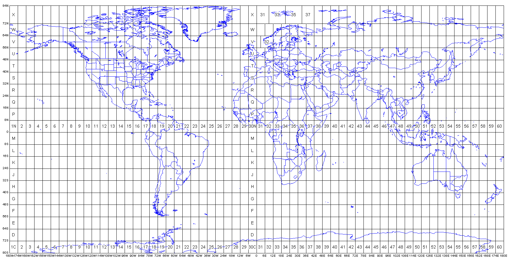
World UTM Grid Zones by Alan Morton

View an enlarged map
MacGPS Pro first needs to convert the geoTIFF image file into PICT format, which while no smaller, is the format used internally by the program. Once imported the file is automatically calibrated by  the user when the correct units (datum: NXZGD2000 and grid: NZTM2000, km, m, magnetic or true) are chosen and the file saved.

Check you have it right by finding the coordinates of a known point on the map and see whether they correspond to that on the TIFF or paper map

View Similar Posts


Creative Commons License
This article by Bush Walker is licensed under a Creative Commons Attribution-NonCommercial-ShareAlike 3.0 Unported License.

Monday, January 17, 2011

Converting Map Coordinates for Bushwalkers | Latitude, Longitude to/from UTM

Ever wanted to understand what the numbers on the lines on your map are? Does your iPhone app only register latitude and longitude and you need to convert it to UTM (Universal Transverse Mercator) or vice versa. Need to be able to tell your local emergency service the latitude and longitude of your location for a rescue?
There are at least three ways to convert between coordinate systems or formats eg UTM grid references to latitude and longitude
  1. using an online Web Converter (see below for examples)
  2. install an iPhone App which does it for you (see below for two)
  3. change your GPS  coordinate format settings and see the converted result
A word of warning from Professor Dutch
"Caution! Unlike latitude and longitude, there is no physical frame of reference for UTM grids. Latitude is determined by the earth's polar axis. Longitude is determined by the earth's rotation. If you can see the stars and have a sextant and a good clock set to Greenwich time, you can find your latitude and longitude. But there is no way to determine your UTM coordinates except by calculation." (Source: Steven Dutch, Natural and Applied Sciences, University of Wisconsin - Green Bay)
UTM
"Universal Transverse Mercator (UTM) coordinate system is a grid-based method of specifying locations on the surface of Earth. The UTM system divides the surface of Earth between 80° S latitude and 84° N latitude into 60 zones, each 6° of longitude in width and centered over a meridian of longitude. Zones are numbered from 1 to 60. " (Source: Clever Applications)
Some Online Web Converters

iPhone Apps
Map Tools screenshot

Map Tools By Richard Hoffman
"Map Tools is an iPhone app  that let users to fully utilize coordinates. Map Tools converts coordinates among various datums, coordinate systems and map projections. It also calculates distance between two coordinates. It supports coordinates conversion between geodetic coordinates, UTM, UPS, MGRS and map projections in up to 232 datums. The app is delivered with WGS84 ellipsoid and used as the default datum. You can purchase an add on that will provide you with an additional 232 datums, which include NAD27, ED50, OSGB36, EGSA87, AGD66, AGD84, GDA94 and a lot more." (Source: iTunes Apps)
NB for Australians WSG84 (supplied) and GDA94 are almost equivalent so if you are only using this datum there is no need to buy the extra 232 datums. 

Bit Map by Nixanz 
Bit Map by Nixanz
Bit Map is a map viewer app with some basic GPS features, and simultaneously provides both the UTM and latitude/longitude coordinates in decimal degrees for any point on the uploaded map you are viewing. While it doesn't convert between map coordinate systems, it will give both for any location and datum.
Read my Review of Bit Map

Using your GPS to convert

If you open the settings field on your GPS, you can change between the coordinate formats offered eg UTM to Latitude and longitude etc and all coordinates entered in the original format will then appear in the new.


Social Bookmarking

Visit my Delicious bookmarks to discover some popular web resources on this topic.

Further Reading

Creative Commons License
This article by Bush Walker is licensed under a Creative Commons Attribution-NonCommercial-ShareAlike 3.0 Unported License.

Tuesday, November 9, 2010

My Favourite iPhones Apps for Bushwalking, Hiking, the Outdoors and Fitness.

For about three weeks, I have been trialling a selection of free and paid iPhone apps, small applications for mobile phones, of which a small number may eventually meet my needs as a keen bushwalker (hiker), photographer and "naturalist".I have been overwhelmed by the variety of apps, their quality,  versatility and value. With a 32GB iPhone, I have plenty of room to experiment!

The key to versatility is the ability of iPhone 4 apps to integrate and multi-task in the background with the inbuilt compass, GPS, accelerometer and gyrometer, camera, video and music player. The high resolution touch screen makes many tasks such as map reading easier.

Some of these apps duplicate functions included in others, but offer them in a more user friendly manner or with more options. Be wary of free apps that include ads that will drive you mad with their insistence that you visit their website or depend for full functionality upon registering for  a website which then owns and shares your information and habits with third parties. Many of the free apps are "lite" versions of the full paid version and are made available so you can test the features before purchase.

In a previous post, I did a Google search and came up with a list of over 60 "outdoors" apps  which I then reduced to a smaller number for download especially those with a local flavour. I have intentionally omitted those that require registration on a website to work and those that can't use the UTM coordinate system, where this is critical. I have included "Lite" versions which allow you to trial the product free of charge before upgrading to the full paid version if you wish.

Over the next few weeks, I will review some of the best in more detail. Those that I have downloaded so far include the following :

Navigation
Gone Trekking Safety Outdoors: location aware safety notification app (Free version available)
MotionX GPS : attempts to bring many of the features of a dedicated handheld GPS, plus a sports and  fitness GPS, plus a geotagging camera into a single app (Free version available)
Map Overlay Tracer: overlay and trace maps directly on top of Google maps
Google Earth: explore your intended or current  location using 3D satellite imagery (free)
GeoLog Tag: acts as a GPS data logger and geotagging app (JPEG and RAW) for photos taken with any digital camera. (Free version available)
Declination: find your current magnetic declination based on the World magnetic mode. (Free)
Bit Map: offline map viewer for your own imported topographic  maps in standard image formats plus oz2 (Australian)
Map Tools: utility that lets users fully utilize coordinates. Converts between datums, including AGD66, AGD84,GDA94, NZGD49, coordinate systems, and map projections and calculates distances.
Convert Units; ideal for converting F to C, miles to km, quarts to litre, or with custom unit conversions km/hr to minutes per mile (Free)
Pocket Pedometer: specifically designed for walkers and runners, automatic movement detection, calibration, distance measure, calorie counter, conversion system. (Free version available)
Orienteering Compass : behaves just like an oil-bath compass with outer locking ring
BackToMyCar
: assures you of never forgetting where you parked again, take photo, turn by turn walking instructions, see distance and time left on meter. (Free)
Service Tools
No Signal: No cell service? In a dead zone? want to be notified when you can make calls again without taking the phone out of your pocket?
Photography
Photonasis has the biggest collection of photo effects on the app store  (Free)
Genius Scan: turns your iPhone into a pocket scanner, great for sending those trip intention forms you have just completed (Free) 
Photo Timer : capture group photos and self portraits
Flickit: keep your Flickr.com photostream up to date
Flickr: shoot, upload and share photos and videos: Geo-tag your photos or add them to a set. View your photos by set and tagBurst Mode: analyse fast events frame by frame eg bird flying
Remotomatic: make your iPhone a bluetooth remote controlled camera with self-timer shutter built-in.
Equipment
Camp and Hike: allows selection from a larger master list depending on duration, weather and type of trip.
ListPro : the ultimate list making toolkit (Free)
Reference
Australian. Birds (Michael Morcombe eGuide): a comprehensive collection of bird calls, sketches and a searchable, location aware database, which allows side by side comparisons.
Bird in hand; covers 23 of Tasmania’s common and endemic birds and includes bird calls, high quality pictures and information on their habitat, breeding, diet etc. Use the App while out bush to work out which call is which.
Star-Guide: displays the constellation to which your iPhone is pointing (Free)
Wikipanion: accessing Wikipedia has never been faster and easier eg do a search for Federation Peak, Tasmania and find out the history, location, climate, climbing routes and get photos.
Fitness
iWorkout Lite: Do you want a personal trainer in your pocket? metronome, pedometer, exercises, videos
Walkmeter: continually records your time, location, distance, elevation, and speed. See your results on maps, graphs, and a calendar, and organized by routes and activities. Monitor your progress with up to 20 configurable announcements including distance, time, speed, elevation, climb. Compete against your previous workouts along a route.
Pocket Pedometer (Free) measures distance, time, calories, steps with automatic calibration for walker. Battery saver turns off screen automatically.
First Aid/Emergency
Gone Trekking Safety Outdoors:  location aware safety notification app
MediProfiles: carry all the emergency medical information you need about your co-walkers in case you need it in a remote location. Published by St John Ambulance (Free)
TuneIn Radio: listen to and record over 40,000 radio stations via the internet including thousands of AM/FM local stations. Want the local weather forecast or fire danger report?
Utilities
Flashlight: the LED light on iPhone 4 and fills your screen with bright white light . Strobe for emergencies. Red light for night use.
KnotsGuidecontains 92 knots divided into 10 categories
Learning the Ropes- Navy Knots learn to tie navy knots with 3D animation and notes (Free)
GoodReader
: use it to view reference documents you have saved from the web. Super-robust PDF reader with advanced reading, annotating, markup and highlighting capabilities, excellent file manager, TXT file reader and editor, audio/video player, Safari-like viewer for MS Office and iWorks files.
Kindle
: gives users the ability to read Kindle books
Library : keep track of and share bushwalking books you have read, books you want to read, and books you are reading. (Free)
BooksApp Lite: easily catalog your entire book library, group related books together, recommend your favorite books to your friends and family and keep track of who has borrowed your books. Uses ISBN and scans barcode to import details including artwork. (Free. Limited)
Climbing Grade Converter : converts grades between 14 climbing grade systems including bouldering (Lite version is free but limited)
Weather
iBarometer: lets you easily know what is the pressure near you, using the internet. Great for calibrating your altimeter.
Pocket Weather AU: weather sourced directly from the Australian Bureau of Meteorology (BOM) Keep up to date with weather alerts and extended forecasts.

Creative Commons License
This article by Bush Walker is licensed under a Creative Commons Attribution-NonCommercial-ShareAlike 3.0 Unported License.